Carding Mill Valley and The Long Mynd Harder Walk
Overview
Great news!
The government guidelines have been updated and we can now increase numbers of walks!
We have therefore increased the numbers on our walks and will monitor how it works with higher numbers.
Importantly, we still have to social distance on the walks.
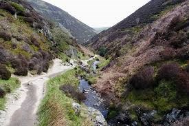
This is a 11 mile round trip with some fantastic views and invigorating climbing. The route quickly climbs out of Carding Mill Valley and up onto the long broad ridge that makes up the Long Mynd and we follow the ancient Port Way before descending to Bridges.
We head south over Adstone Hill and on to the village of the Medlicott, before hauling ourselves up to the Shropshire Way on Pole Bank.
An elevated ridge walk then takes us over the highest point before descending back to Carding Mill valley and the excellent National Trust Café, having earned an extra large slice of carrot cake.
Notes: Walking poles may help when descending. Good hiking footwear is essential for this walk. A water bottle will be useful. Toilets at the start, and may be available at Bridges if the Three Horseshoes pub is being friendly.
Extras
Public Pay and Display car park will charge £4 for the day, free for National Trust members. (There is free parking by the train station SY6 6PG and it is then a 20min walk up to Carding Mill Valley.)
Directions
From Birmingham: M6, M54, past Telford towards Shrewsbury. Take A49 south at large roundabout with Dobbies Garden Centre. Stay on A49 to Church Stretton. Right at traffic lights on edge of village by petrol station. Then 2nd right on to Shrewsbury Rd. Then look for brown sign pointing left up Carding Mill Valley.
By Train: Birmingham New St to Church Stretton, change at Shrewsbury. Takes about 90mins, one leaves at 8.25am gets in around 10am. Follow road (Sandford Ave) into village, right at top on to Shrewsbury Rd, then left after 400yds up Carding Mill Valley. (Will take about 20 mins on foot)
Host & Everything Else
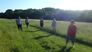
Gallery